Imbolc: Of Ewe’s Milk, Brigit and Swans

Half-way between the Winter Solstice and the Spring Equinox, the astrological point of Imbolc heralds the first stirrings of spring. Delicate bell-shaped snowdrops push up through Earth as hard as iron at this the coldest point of winter, and candles are lit for the returning Sun. The festival was celebrated with ewe’s milk, the first fresh food of the year and produced as lambs appear from the ‘tupping’ at Samhain. Indeed, the feast probably gets its name from the old Irish word imbolg, meaning in ‘the belly’, referring to the pregnancy of the ewes.

This Celtic festival belongs to the mother goddess Brigit, daughter of the Dagda and in her triple aspect patron of healers, smiths and poetry, seen as guardian of the oral tradition by which all sacred knowledge was mediated. Brigit was sometimes depicted as a milk maid, milking the sacred cow, the bringer of nourishment and plenty but taking what is needed, never too much. In this role as ecological protectress, or Sovereignty goddess, she is the maiden aspect of the Cailleach, the hag who ruled over winter but was transformed into a beautiful maiden at spring, bringing rains and fertility as the Bride.

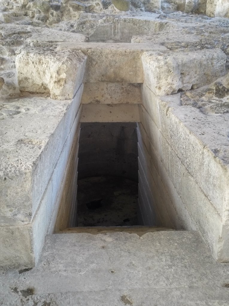
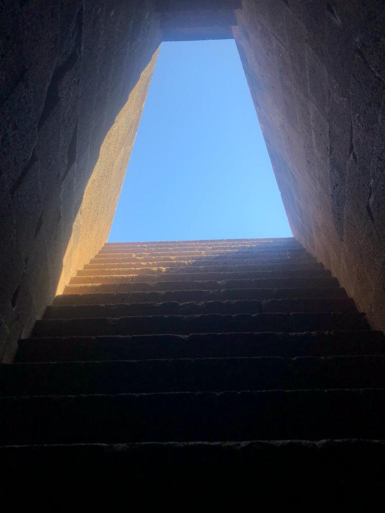
One of her most significant roles was as guardian of the wells, seen by the Celts as the sacred gateways to the Otherworld from which the source of spiritual as well as physical nourishment arises. Imbolc was therefore traditionally a time to dress wells and honour the sacred gift which they bestowed. Many wells in Britain still bear her name, most famously St Brides of Fleet Street in London, though there are also many local well goddesses around the British Isles, for example Sulis at Bath and Coventina in the North. Churches were often built over these ancient healing sites and this way, Brigit was subsumed into Celtic Christianity and became Saint Brigid, taking  1st February as her feast day and establishing a sanctuary on the ancient site at Kildare. Here  nineteen nines tended the Sacred Flame all year, with Brigit herself said to come on the 20th night. This sacred fire was kept alive from at least the four century through the early medieval period, until abolished by Henry VIII in Tudor times.

As goddess of spring and new growth, Brigit was often associated with childbirth and in a curious mingling of pagan and Christian traditions, she became known as the foster-mother of Jesus. According to one legend, when Christ was lost in the Temple she helped Mary to find him by making an augury as follows:

‘The augury of Brigit made for her foster-son. She made a pipe within her palms;

‘I see the Foster-son by the well’s side, teaching the people assuredly.’ [1]

Candlemas, the Christian equivalent of Imbolc, was associated with the purification of the Virgin Mary forty days after giving birth to the infant Jesus, later known as Churching, the time when women were allowed to resume normal life after birth. This custom could have evolved from Judaism with its emphasis on ritual cleansing, and indeed it has also been suggested that another origin of the name Imbolc was derived from imb-fholc meaning to wash or clean oneself. Today we often feel need to spring clean our houses at this time, to sort through what is needed and what can be released in preparation for receiving the new life experiences of the coming year. It is highly likely that origins of both customs are even more ancient and could be linked to a proto-Indo-European word meaning both ‘milk’ and ‘cleansing’, potential evidence for a deep-rooted association.[2]

This could also explain why Brigit the Milk Maid was also linked to the celestial stream of milk that flowed with abundance across the night sky, the Milky Way. As ever, there is an ecological aspect to this myth, for February was the time of year when the swans started to depart for the Arctic after their winter sojourn further south, flying overhead as the constellation Cygnus does along the Milky Way. This would have been an awesome site, flocks of large winged birds flying north in huge formations, off to the mysterious north, unexplored lands of ice and fire.

As guardians and keepers of these mysteries, swans were known as one of the sacred birds of Britain and many customs today enshrine their importance to the land – for example, the Swan Upping ceremonies conducted each year on the Thames. As a result of their mysterious flight patterns, they were also considered to be threshold creatures, guardians of the mysteries of the celestial world, as psychopomps, said to accompany souls on the journey to the afterlife. The swan song, the mythical melody of the dying swan, has long been symbolic of the final act of the soul before its departure. Their association with the constellation Cygnus, gateway to the Dark Rift of the Milky Way and guardian of the mysteries of the North has very ancient origins, and flutes in the shape of swans have been found in Ma’lta Siberia that date back 25,000 years. It is also possible that ancient temples such as Gobekli Tepe in SW Turkey were aligned to Deneb, one of the stars of Cygnus, which was circumpolar during the last Ice Age and seen as a portal to the sky world, potentially as a source of cosmic creation.[3] We are only just now beginning to understand the intricate and ancient mythology of Cygnus the Swan.


[1] Caitlin Matthews, 1989, ‘The Celtic Tradition’

[2] Sharon Blackie, 2020, ‘This Mythic Life’

[3] Andrew Collins, 2018, ‘The Cygnus Key’

The Baalbek Enigma

The sanctuary of Baalbek was one of the most famed sites of the ancient world and the well-preserved ruins are still capable of inspiring awe and wonder to this day. Roman emperors would make pilgrimage to the largest of Rome’s temples, situated not in the Eternal City, but in a remote valley sandwiched between the Lebanon and ante-Lebanon mountain ranges. Though Baalbek is still a major attraction, for decades its proximity to the Syrian border and a nearby Hezbollah training camp have made it largely inaccessible to all but the hardiest of travellers. Now, as tourism returns to the Lebanon, its mysteries are again being slowly revealed.

The Propylaea, author’s photo

Nobody would deny that the Romans were master builders, the engineers par excellence of the ancient world. It took the Julio-Claudian emperors over 200 years to build the sanctuary that consists of  temples dedicated to the Roman triad Jupiter, Bacchus and Venus, plus two massive courts, sacrificial altars and basins for ritual cleansing. The vast scale of the complex, the intricacy of the decoration and the sheer height of the six remaining Corinthian columns of the Temple of Jupiter, the largest in the Roman world, cannot fail to impress.  Still, the enigma of Baalbek lies not so much in the wonder of the temples, but in the presence of three gigantic stones comprising part of the wall that surrounds them.

The Trilithon, photo public domain

Approximately 64 feet long, 14 feet high and 12 feet the three stones embedded in the north end of a U-shaped megalithic wall surrounding the Temple of Jupiter are collectively known as the Trilithon. They have been laid with such a precision that ‘even a needle would not fit in between them,’ yet each stone weighs in excess of 800 tonnes, weight that even modern cranes would struggle to move[1]. So, who put them there, how did they do it and what purpose did they serve?

The theories are many and varied. Though the Romans have left no written record of how the Trilithon was moved and why, the most standard line is that it was them who emplaced them, intending the U shaped wall to form part of a podium which presumably was never completed, which in turn incorporated the remains of an even earlier podium[2]. Another theory is that the Romans built the megalithic wall as a restraining wall to stop soil erosion and prevent movement on the vast temple complex [3]. Other researchers doubt that the Romans had the technology to move the massive blocks from the nearby quarry and attribute the building of the wall to an Elder culture who had highly developed building skills learnt before the Great Flood, and who could have also built another Cyclopean structures around the globe.[4] Other theories credit the construction and engineering of the Trilithon wall to giants, jinn or extra-terrestrials who used magnets and sound technology to move the stones.[5]

‘The Stone of the Pregnant Woman in the quarry near Baalbek, author’s photo

Many researchers more qualified than me have pondered deeply about the logistics of moving and emplacing such massive stones, but surely that the Romans possessed the know-how to move gigantic blocks and emplace them is not in doubt, as the massive columns in rest of the sanctuary testify. And they could also have simply built the megalithic wall as a retaining wall, practical as they were. But I am equally comfortable with the notion that an earlier culture could have built the wall too, and that massive structures in Egypt and South America show levels of engineering capabilities that equalled, even surpassed, that of the Romans. New and intriguing structures from prehistory are coming to light all the time (e.g. Gobekli Tepe in Turkey) and gradually we are able to flesh out in more detail the mysteries of our past. But for me, after the visiting the site, the enigma of Baalbek changed from how and by whom, to why and why here?

Temple of Bacchus, author’s photo

So, who was here before the Romans? Everyone would agree that Baalbek was considered sacred long before they arrived. Named Heliopolis by the conquering Alexander, the Greeks equated it with the Egyptian City of the Sun, a place of great antiquity by this time. The Canaanites had been present in the area for centuries and used the hill at Baalbek as the centre of one of their sanctuaries. And the Phoenicians, an off shoot of the Canaanites, also considered the site to be sacred and built temples to Baal, Astarte and Adon(is), here.  Indeed, the altars of the Roman Great Court were built over the exact summit of the hill used as one of the Canaanite  ‘high places’ and care taken to raise the platform so it was the same height. Archaeological evidence has shown almost continual occupation of the tell over the past 9,000 years and evidence of occupation during Paloelithic times has also been found.[6] But why here?

Spring at Baalbek, author’s photo

Next we need to look more carefully at Baalbek’s location in the Beqaa Valley and dig deeper into the local geology. Located in the centre of the cradle of civilisation, the NE Beqaa was a cross over point on trade routes from Tyre to Palmyra in the Syrian desert, or from Damascus to Beirut, bringing a constant flow of people and ideas to this area that was known for its fertile soil. It is located between two mountain ranges, and close to the source of two rivers, the Litani and the Orontes, was deemed highly auspicious by the ancients, and one of the possible locations for the abode of El in the Ugaritic Baal Cycle.[7]  Finally, Baalbek is also near a well now called Ras al Ain (‘head of the source’), which in ancient times was associated with the dragon Typhon. [8]

Dragons are usually associated with very powerful Earth energies, and this is an apt description of the Beqaa Valley. Situated at the top of the Great Rift, the valley is in close proximity to (indeed was pushed up by) a long fault line that runs through the Lebanese mountain range bringing frequent earthquakes to the region as the converging African, Eurasion and Arabian microplates twist in opposite directions. The power of nature in this region is literally awesome and must have inspired wonder, and not a small measure of fear, in our ancestors. In addition, the natural springs fed by meltwater runoff from the ante Lebanon mountain range frequently overflow, bringing flooding as well as earthquakes to the Beqaa.

As a site of potent Earth and water energy, Baalbek was also an oracular site of great antiquity. The Romans took over this cult wholesale and used the Temple of Jupiter as an oracle, famously consulted by the Emperor Trajan on two occasions, who asked if he would be victorious against the Parthians. It was also a site of cosmic importance, for there are reports from travellers that the Canaanites had a temple housing the sacred ‘betyl’ or meteorite stones that ‘were endowed with life’ and probably used for oracular purposes. [9] Thus as a place of great dragon and water power, as a sacred link between heaven and Earth, Baalbek was clearly a sacred site par excellence.

Entrance to the Temple of Bacchus, author’s photo

It is well attested that the natural calamities that befell the people of the Bronze Age resulted in a shift in human focus from living according to the principles of nature, to attempting to dominate. My sense is that the megalithic wall, and massive Trilithon stones, were emplaced for this reason, to try and control the vast and awesome forces at play in the Valley. Whether the Romans built the megalithic wall or not, they certainly built to impress and dominate, harnessing the power of the potent sun god (Jupiter) and the wild god of bacchanalia (Bacchus) to this end. To build such an imposing monument on this site of great Earth energy was clearly deliberate.

Over the past two thousand years, many more earthquakes and flood have ravished the land, and waves of conquerors have passed through, leaving their own mark. In more recent times, politics and agendas in neighbouring countries have become more intense and today the Beqaa Valley is one of the most poignant places in the Middle East. Though still a place of natural abundance and beauty, warlords use the land to grow cash crops of cannabis, marijuana and heroin, and Syrian refugees live in makes shift tents and farm the land in all weathers to earn money to send back to the ruin that is now Syria. Pictures of Nasrallah and the yellow flags of Hezbollah line the streets, and the Israelis nervously monitor the training camps that give the valley the name ‘barracks of Hezbollah.’ According to a recent article in the Jerusalem Post [10], Hezbollah are building a precision missile building site here, but I have no means of verifying this (itself a sign of our times).

Once one of the most sacred places in the Middle East, it now feels like one of the most distorted. This to me is the true enigma of Baalbek and the key to this lies not in understanding the technology used to shift large stones, but in the intentions used to emplace them.


[1] Graham Hancock, ‘Magicians of the Gods’ p. 239 – 291

[2] Graham Hancock, ‘Magicians of the Gods,’ p. 239 – 291

[3] See http://www.ancientaliensdebunked.com/Baalbek

[4] See ‘Baalbek – Lebanon’s Sacred Fortress’ by Andrew Collins (available at andrewcollins.com)

[5] See, for example, Alan Alford, ‘Gods of the New Millenium.’

[6] Baalbek https://en.wikipedia.org/wiki/Baalbek

[7] As above

[8] See www.Livius.org (accessed 20.9.19)

[9] Graham Hancock, ‘Magicians of the Gods,’ p. 239 – 291

[10] The Jerusalem Post (online), 5.9.19

Lebanon: the lost rites of Astarte and Adonis

The Lebanon is not your average Middle Eastern country, though it embodies aspects of them all. Today it is a melting pot of Sunni and Shia Muslims, Palestinians, Druze, Maronite and Orthodox Christians, Syrian refugees and wealthy Arabs from the Gulf, but beneath the vibrant surface it is possible to discern the traces of an equally unique and rich past.

‘Astarte’ the Louvre, Paris (public domain)

For thousands of years it was the Canaanite and then Phoenician cultures that flourished in this tiny sliver of land sandwiched between the Mediterranean and two large mountain ranges. This was the time when Astarte, Queen of Heaven, was worshipped as a goddess of fertility and sexuality, bringing abundance from the sea and nourishment from the land, and ensuring together with her consort Baal, that all things were in balance above and below. She herself was derived from the older Mesopotamian goddess Inanna and it was this archetype that was worshipped throughout the Levant in various forms including Ishtar, Ashtoreth and Aphrodite.

‘Jezebel’ by Byam Shaw, public domain

Today little traces of her remain either physically or in the historical record, and what does is often recorded through the lens of disapproving historians or biblical writers. One of her most famous priestesses was Jezebel, the Phoenician princess and daughter of King Ethbaal of Tyre, who took the worship of both Astarte and Baal to the kingdom of Israel at the time of the prophet Elijah. Astarte ruled supreme in all the city states of Phoenica and in the Eschmoun temple near Sidon (named after her consort in this city), a well-preserved temple still stands to this day. She was typically worshipped in the form as a throne supported by winged sphinxes or lions, and represented by a betyl, or sacred stone. It was at Byblos, however, that her main centre of worship was located and it was there that I went to piece her story together.

Astarte’s throne, National Museum Beirut (author’s photo)

The ancient ruins of Byblos are vast and impressive and in the centre of the complex, reached by a grand central colonnade, the temple of Astarte once stood. Reconstructed images show a large open court, surrounded by cloisters, in the middle of which stood a large conical shaped stone, or betyl, that represented and embodied her essence. It was here that the famous rites of Adonis were celebrated, generally seen as the ‘offspring’ of Baal and Astarte, or sometimes as her lover. The name Adonis means ‘lord’ in semitic and though introduced at a later stage by the Greeks and Romans, nevertheless embodied a hugely powerful archetype that also went under the names of Tammuz and Attis.

These young male gods embodied the ‘rising and dying god-man archetype,’ an archaic form of a vegetation deity that has very deep roots. According to James Frazer[1], as harvest gods, they embodied the actual life essence present in the corn and were ritually slain once a year as the corn itself was threshed by scythes and cycles at harvest time. The death of the harvest god was then ritually mourned in a huge ceremony involving cymbals, flutes, and semi-naked women beating their breasts, dancing and weeping in a sacred lament, followed the burial of his wounded body, and then the celebration of his miraculous resurrection the following day.

In the Greek version of the legend, Adonis was born of a myrrh tree (confirming his status as a vegetation deity) and hidden in a box by Aphrodite in the underworld. In a story woven into the mythology of many cultures across the aeons of time, but with local varieties of gods/goddesses playing the part, he is held hostage in the underworld until permitted by an authority figure to spend part of the year above ground, thereby embodying the mysteries of the seed that lies fallow before bursting forth in the spring in the abundant glory of the corn crop.

‘Venus and Adonis’ by Titian, public domain

The next part of the legend is specific to the Lebanon, for we are now told that the youthful Adonis, who loved to hunt, was out on Mount Lebanon near a place called Afqa. He came across a wild boar, that fatally wounded him in the leg. Aphrodite herself could not save him from his injuries and he bled to death on the ground, causing crimson anenomes to spring forth and the river water to run red with his blood. This river was known as the Adonis river in antiquity and flowed from Mount Lebanon through the Aphaca gorge down to Byblos, where it emptied into the sea.

Afqa waterfall, author’s photo

According to Frazer, there was once a large temple of Astarte that stood in a grove near the source of this river, and one hot day in August, I journeyed to Afqa to see what fragments remained. Though I found no trace of the temple, I did find a place of incredible beauty. Set in the towering limestone massif of the Mount Lebanon range was a huge cavern from which a waterfall emerged. Even in August the waterfall was an impressive site forming pools of azure and turquoise water, but in the spring, when the pale sun starts to melt the snow on the top of Mount Lebanon, the frothing waters would have burst forth in torrents, cascading down the valley, fructifying and turning all the vegetation green after the barrenness of winter. It was here, according to the legend, that the wounded body of Adonis was buried, dying so that the vegetation might spring forth.

It is clear from the stories that the blood of Adonis not only fertilised the land but also turned the river red. Upon closer inspection of the waters, traces of iron can be seen and we now know that the soil around the river is rich in iron oxide. As the water levels rise, iron rich soil is washed into the water, turning it the colour of vermillion. This bloody torrent then then snaked down the Aphaca gorge, and on to Byblos where it fanned out to sea, and, in the words of Frazer, “fringing the winding shores of the blue Mediterranean, whenever the wind set inshore, with a sinuous band of crimson.’

Adonis Cavern, Afqa (author’s photo)

And that is not all. As also Frazer suggests, there was a celestial event that accompanied the torrents of water that emerged gushing like blood from the cavern at Afqa, and this could be linked to the planet Venus. According to the historian Sozomen [2] ‘At Aphaca, it was believed that on a certain prayer being uttered on a given day, a fire like a star descended from the top of Lebanon, and sunk into the neighbouring river; this phenomenon they sometimes call Urania, and sometimes Venus.’

Astarte/Aphrodite were closely associated closely with the planet Venus, and the cycles of Venus were well known to the Ancients who considered her retrograde motion then reappearance as the morning star to be mysterious and sacred. It is therefore plausible that at certain times of the Venus cycle, the star was seen from the lofty heights of Mount Lebanon to fall from the night sky and plunge into the river, turning the waters blood red. To the ancients, Astarte would have personified the planet Venus, who fell from heaven to lie in the arms of her lover Adonis, fructifying the barren Earth in a cosmic drama of great potency.

Throne of Astarte at Echmoun Temple, Sidon (author’s photo)

On an even deeper level, it is possible that these rites originally recorded a meteorite impact that occurred in archaic times. Then the falling ‘star’ would have had a physical impact on the Earth, ‘wounding’ it and causing the river to run red with blood. It could also have fructified and brought forth new life, just as the poppies used today to symbolise death and sacrifice rose from the desolate battle fields when they were first ploughed. Furthermore, Astarte herself was represented by a betyl, and the most prized betyl of all were those made from meteorites. They truly were a piece of heaven on Earth and our ancestors understood their significance in a way that has been lost today. In the stories and legends that have come down to us from antiquity, we can therefore piece together traces of a lost world view that saw heaven and earth as a unified whole, and our place in nature as sacred and wondrous.


[1] James George Frazer ‘The Golden Bough,’ Oxford University Press, 2009.

[2] See www.phenicians.com ‘The Adonis legend’

The Sacred Well Temples of Sardinia

Sacred Well Temple (author’s photo)

Of all the sacred sites of Sardinia, the sacred water temples are the most beautiful, and the most unique. They were built by the Bronze Age Nuraghic culture (approx. 1800 – 238 B.C.E.) famed for the numerous Cyclopean towers and huge fortified villages that pepper the island to this day. The primary purpose of these structures was to protect against invasion, but these master builders wove aspects of the existing goddess culture into their fabric, aswell as developing new ones such as the sacred well temples.

It is generally recognised that the Nuraghic culture evolved from the pre-existing Chalcolithic people of the island, but as they were great sea farers and traders, they were certainly influenced by the other Mediterranean cultures of that time. Known as the Tower People, they had something in common with the Mycenaeans of Ancient Greece, who were also building beehive structures containing circular tholos. On Sardinia, the nuraghe, or defensive towers, contain a central tholos, often with side chambers, and circular openings at the top to the heavens. Long passageways within the tholos are often trianglular and feel like a primal birthing canal, designed to take the dead chieftains back to the primal womb of birth/death.

Sacred Well, Perfugus (author’s image)

Though the Nuraghe are numerous, there are only a handful of surviving sacred water temples and they all contain unique and interesting features. In Purfugas there is a small but exquisite sacred well made from marble. Located in the centre of town and surrounded by a fence, entrance is only possible with a guide from the archaeological museum who provides a key to gain access.

The well is circular and open to the sky now, but reconstructed images show it situated within a stone tholos during Nuraghic times. At the entrance to the structure there is a small rectangular vestibule with seats and a small votive table, both made from marble, where offerings to the water goddess would have been left. A beautiful bronze bull and ox were found at the site, both symbols of fertility and abundance.

Well floor, Perfugus (author’s photo)

Entrance to the well itself, which is a perfect circle, is via eight skillfully constructed marble steps. Descending into the hypogeum, where once the sacred water rites would have occurred, is like descending into the sacred abyss or underworld from which all life emerges, and the love and devotion once present in this sacred well is still palpable.

There are other sacred water temples in the south of the island, but it is the well at Santa Cristina near Paulilatino that is the best preserved and most spectacular of them all. Situated right next to a junction on the Sassari to Cagliari motorway, the well is not remote but still capable of transporting you to another realm. It was built in around 1200 B.C.E. and is made from basalt, giving it a more earthy and firey energy than the well at Perfugas. It is surrounded by an elliptical low wall and when seen from above, the structure resembles a vulva with the trapezoid shaped entrance to the well itself resembling the vaginal opening.

Well floor, Santa Cristina (author’s phot)

As with the well at Perfugus, the precision and craftsmenship of the structure is exquisite.  Access is via a dromos, or vestibule, which leads to a trapezoid opening and twenty five smooth basalt steps lead down to the hypogeum floor. The sacred spring at the heart of the sacred water cult is still active today and laps the bottom few steps, and a large tholos is situated over the well with a carefully positioned hole. Most remarkably of all, some researchers (see http://www.ancient-wisdom.com) have suggested that the hole in the top of the dome is aligned to reflect the light of the setting Moon at its maximum declination every 18.6 years when it appears to reach lunar standstill. This detailed understanding of one of the Moon’s lesser known cycles shows how intimately the sacred water rites were linked to Moon worship, which is, as far as I know, unique amongst the many sacred sites of the Mediterranean.

Trapezoid opening, Santa Cristina (author’s photo)

The sacred water temple iself is part of a larger complex and is surrounded by circular gathering huts which could have been used for ritual purposes, or purely civic activities. Archaeological excavations have shown that the site was used by the Phoenicians in around 1000 B.C.E., as four bronze statues of Phoenician healing gods and goddesses were found during excavations. It is therefore possible that the Phoenician had some sort of influence in the building of this site, especially as the Phoenicians had a strongly defined Moon and sacred water culture that did not appear to be in existence on Sardinia before this time (though this is purely speculation).

This incredible site has been held sacred for over three thousand years, and still is today. As a pure lunar, womb and sacred water site it has the remarkable potential for healing on an energetic level some of the wounding inflicted by the solar warlike Bronze Age energy, as those who descend into its depths with an open heart can testify.

The Wellsprings of Sark

Water is the life blood of the planet and its presence will determine whether civilisations survive or perish. It is therefore not surprising that the streams and wells that provide fresh water have long been honoured as sacred, as a source of life itself. On small islands like Sark (Channel Islands) where there is no mains water, residents are dependent on wells and boreholes to fulfil their needs. One lovely spring day, I set off to explore the streams of the island and find the wellsprings that feed them.

The Monk’s Well, Seigneurie pond (author’s photo)

It seemed fitting to start at Sark’s most famous well at the Seigneurie pond. Known as the Monk’s Well and located between La Moinerie and L’Ecluse, both potential sites for the original monastery, I was delighted to find that the pond had been recently cleared and looked beautiful in the morning sun.  The Monks Well was full of water, and the wellspring just behind it bubbling freely through a crack in the rocks, a visible expression of the underground water coming to the surface. The wellspring feeds the pond, and in turn a stream that flows through the valley by L’Ecluse. The water was flowing fresh and fast, and I followed it down through the valley as it splashed and gurgled its way across the stones, winding down through the bluebells and wild garlic then emptying into the sea at Port du Moulin. Further down the path I found the location of the dipping well, so named because passers-by would dip a cup in the waters to refresh themselves on their journey.

Wellspring in the field under the Manoir (author’s photo)

Though the current Seigneur lives at the Seigneurie, the early Seigneurs lived at the Manoir in the centre of the island. This is also where evidence has been found for both Neolithic occupation (around 4200 BC) and a Bronze Age settlement (1400 BC), both of which indicates that water must have been readily available here. Though today the area round the Mill is the highest part of the island, it could have been much lower in the past. According to local geologist, Ray Smith, the water table could have been so near the surface in this location that freshwater was readily available, maybe even forming a pond or lake of some sort. Indeed, he speculates that all the streams of the island could have originated from this point. It is certainly the case that a large stream flows down below the Manoir and through the Dixcart Valley, where the wells at Stocks Hotel and Petite Dixcart make use of this supply. Today the wellspring at the top of the valley sits in the field below the Manoir, where a stone well marks the spot.

It is remarkable that there is any water at all on the Isle of Sark. Porous rocks are like sponges, but igneous rocks cannot hold water in the same way, and Sark is comprised solely of igneous rocks. Luckily, though the rocks are hard – hence their preservation at the interface of the Atlantic Ocean and the English Channel – they are also extremely ancient and bear the scars of millions of years of compression, burial, and uplift in the form of folds, faults and cracks. Rainwater finds its way through the cracks, flowing and seeping ever further down, a consequence of both gravity and density. It takes around twenty years for rainwater to seep down to the level to which boreholes are dug, and around one hundred for it to reach its lowest point and assemble in an ‘aquifer.’ On Sark, all the rainwater collects in a giant bowl beneath the island, floating precariously on salty sea water which is denser and therefore sits lower. The balance is maintained only by equilibrium, which can easily be disturbed; the fresh water could simply drain away into the surrounding ocean, emptying the aquifer as easily as pulling a plug in a bath.

Well at Beauregard (author’s photo)

As water is distributed all over the island at depth, it is possible to dig a well anywhere and find water. Consequently, as most people live around the centre of the island, there are many wells and boreholes located on private land here, which are not readily accessible. I did find, however, an old well near the Valette tenement, probably the source for the stream that runs down harbour hill, and a well under the Aval du Creux hotel. There is a famous well at Petite Beauregard, pictured here in 1880 and today, where all the surrounding land has been cleared. The well still has water in it. There is also an old well at the Sablonnerie, just outside the tea gardens, and one at La Donellerie. I am sure that there are many other old and well-tended wells around the island just waiting to be explored.

Wellspring at La Fougeraie

In the North East of the island, another stream flows past the Fort and drains down into the bay at les Fontaines. The Wellspring is located in the bog garden at La Fougeraie, where a lovely well stands today. For many years eels were a feature of Sark’s freshwater and they could be spotted swimming in the streams or occasionally trapped in the sand beds that form part of the water filtering system. At La Fougeraie, two eels were frequent visitors to the well, and in 2011 Roseanne Guille painted a stunning picture of one of them, beautifully capturing the distinctive blue of the creature that Rosanne described as the ‘colour of a cloud heavy with rain.’

‘Eel in the well at La Fourgeraie’ by Rosanne Guille

In Celtic tradition, Wells were thought of as gateways to the Otherworld and the magical fish that lived in them would sometimes appear as harbingers of this world, brining messages to those living in the world above. These two eels seemed to me to be such magical messengers. But legend tells us that the Wells must be tended, honoured as a source of life, for if not the land will be blighted, turned to Wasteland.  The eels were a sign that the waters were healthy and clean, but sadly, when the well was disused in favour of a bore hole, the waters became polluted and the eels died. Now they are very seldom seen in the waters of Sark, neither do they inhabit the wells.

There is a strong sense of hope, nevertheless. The Well at the La Fougeraie is now full of water, crystal clear and the same beautiful blue as the eel in the painting. And the Monk’s Well at the Seigneurie is tended and cared for again. Maybe Sark has been blighted by the Wasteland, but as it Wells continue to be nurtured and honoured as its life blood, so the abundance and riches will keep returning.

St Edith: Murder, mayhem and Bluetooth

St Edith’s well is a beautiful spot in the heart of the peaceful village of Kemsing near the North Downs. According to tradition, just over one thousand years ago Edith, a Saxon princess, spent her childhood in the village, and ‘hallowed by her presence, the waters were made healing.’ However, closer investigation revealed a more complex story linking Edith to a turbulent part of British history that was to set the scene for the Norman invasion seventy years later – and another story with a surprising modern-day twist.

St Edith’s Well, Kemsing (author’s photo)

Though accounts vary, it is widely accepted that Edith was the illegitimate daughter of King Edgar of England and a woman called Wulfthryth, who Edgar kidnapped from a nunnery at Wilton Abbey. Edgar, presumably smitten by her beauty, brought Wulfthryth to his manor at Kemsing, where she gave birth to a daughter called Edith in due course. As penance for this sinful event, Edgar was forbidden to wear his crown for seven whole years. [1]

Aside from this impulsiveness, Edgar the Peaceful seems to have been a strong and able king, unifying the country and developing institutional structures that were to endure for centuries. Shortly after an elaborate coronation that marked the culmination of his reign, Edgar died and was buried in Glastonbury Abbey. Conflict immediately erupted as Edgar left behind two sons – by different wives. One was Edward, son if his first wife Aethelflaed and the second, Ethelred, by his queen Aelfhryth who had been crowned alongside him in 973 AD. Edward the eldest son was given the crown but many nobles supported Ethelred, the acknowledged heir.

Life of St Edith (author’s photo)

It came to a head two years later. One night in 978, Edith dreamt that she had lost her right eye; it turned out to be the exact same night that Edward, her half-brother, was murdered in Corfe Castle. According to the Anglo-Saxon chronicles, he was visiting his step mother and brother when the murder took place, causing some to lay the blame with Aelfhyrth herself. In the ensuing confusion Edith herself was (allegedly) offered the crown by Edward’s supporters, but modestly refused. In any case, Ethelred became king, and made no attempt to bring the perpetrators of the crime to justice.

Ethelred’s rule was to become one of the longest in our history, but it was far from peaceful. The Vikings came back to attack the south coast, carrying out a brutal campaign of terror throughout the 980s until eventually Sweyn Forkbeard, King of the Danes, succeeded in (temporarily) driving Ethelred out. He fled to Normandy to the kin of his wife Emma, establishing a Norman connection that was to change the course of history in 1066. After his son, Edith’s nephew, was to reign briefly as Edward Ironside, then in turn her great-nephew Edward the Confessor.

Edith died around 987 but continued to exert influence from beyond the grave. She is said to have appeared to the archbishop of Canterbury, the famous Dunstan himself, and told them that her body lay uncorrupted. Some accounts say that he exhumed the body to check, and she was canonised, supported by her nephew Edward Ironside. Her thumb was removed from her body and became an important relic. Even the Danish king Canute was said to have venerated her and asked for her intervention during a stormy crossing of the North Sea.

During her short life, she lived through the raids of another famous Viking King.  The father of Sweyn Forkbeard (above) was one Harald Bluetooth, so named on account of a rotten tooth that appeared black and blue. Back home, as the king of both Denmark and Sweden, he had succeeded in unifying the various Danish tribes, an act that was to resonate with some of his fellow country-men one thousand years after his death.

During the 1990s, several tech companies including Intel, Ericsson and Nokia were trying to standardise short range radio technologies and unite all their competing efforts under one umbrella. Ericsson engineer Sven Mattisson stumbled upon the historical Harald Bluetooth at this time, a fact that he communicated to fellow Intel engineer Jim Kardach. The rest is (modern) history.

Bluetooth rune (credit: realrunemagic.blogspot.com)

‘The name Bluetooth was borrowed from the 10th century, second king of Denmark, King Harald Bluetooth who was famous for uniting Scandinavia just as we intended to unite the PC and cellular industries with a short-range wireless link… Harald had united Denmark and Christianised the Danes. It occurred to me that this would make a good codename for the programme,’ Kardach wrote in a column later.[2]

Today Bluetooth is still the official name for the standard, and the world-famous logo is derived from the Nordic runes for H and B. Harald Bluetooth. So now when I visit St Edith’s well in Kemsing and take out my phone to take a picture of the springs, I will be reminded of connections past present and future, and marvel at how small the world can appear, thanks to radio waves and micro waves and the Anglo Saxon Chronicles.


[1] www.wikipedia.org ‘Edith of Wilton’

[2] www.techworm.net ‘Why is Bluetooth called Bluetooth?’

Iceland – Earth, Air, Fire, Water

Iceland is a magnificent example of the interplay of the four elements, and how simple principles such as hot air rising and cold sinking combine to produce a breathtaking array of nature environments, and the habitats to support complex and rare life forms. Its geology is unique in the world; nowhere else do you get a mid ocean ridge, by definition usually on the ocean floor, and a hot spot (or mantle plume) in the same place, and it is also where the Eurasian and American plates meet and are pulling apart at the same rate as finger nails growing. These two features alone are very exciting as they enable us to study at first hand, without getting too remote or wet, mechanisms that could have operated early in planetary formation.

The formation of oceanic crust is the most basic and proliferate process on Earth. Magma wells up from the mantle at constructive plate boundaries and solidifies to form the ocean floor, pushing up large underwater mountains in the process. In Iceland a ridge of this sort rises about 3000 m above the floor, emerging in the Reykanes peninsula in the tip of southwest Iceland, quite close to Keflavík airport, and zig zags across the country forming a rift zone, before plunging deep into the Arctic Ocean in the north. On this peninsula it is therefore possible to ‘hold up a trans-continental bridge’ and its almost ferocious geological activity enable us to ‘blow hot sulphurous air.’

Another famous place to see the spreading ridge at close hand is in Thengvellir National Park, easily accessible as part of Iceland’s Golden Circle. It is also the site of Iceland’s first parliament, the Alping, probably one of the oldest parliament’s in the world. And all of this on a spreading ridge between two continents.

Though basalt is a very common rock type, the varieties in which it can manifest are what gives Iceland its awesome beauty. From blocky lava fields resembling lunar landscapes, infertile and barren, olivine tholeiites have been squeezed up from the upper mantle by decompression melting. Sometimes more regulated, the basalt forms orderly layers resembling a chocolate and coffee cake, stretching for miles along ancient eruption fissures.  Infertile lava and ash deserts crunch underfoot like glass, turning easily to dust, but when water is present, tiny white flowers grow in proliferation, carpeting the basalt. Gently undulating volcano slopes covered in mossy green fuzz, sometimes hues of purple, roll for miles, perfect cones loom up from rubble landscapes and others are more craggy, bearing witness to more powerful and inconsistent forms of erosion. At Myvatn, pseudocraters have been formed as a result of lava flowing over damp ground and causing it to bubble up and form cone shapes, and nearby mud pools have been formed from solidified clay.

Along the south coast, weathering and erosion has formed spectacular black sand beaches as far as the eye can see. At Vik, surely Iceland’s most beautiful beach, basalt has organised itself into its most spectacular form, that of hexagonal basalt columns, glistening like black organic pipes covered in exuberant frothy foam from the crashing Atlantic waves, and there are also rugged sea stacks just off shore to admire, one of nature’s sculpture. In the cliffs about the basalt, puffin colonies nest wheeling busily overhead as they fly out on stormy air currents above the turbulent waves. In the western fjords, it is also possible (though rare) to spot a sea eagle, and gyrfalcons can also be seen in the more mountainous areas.

Water is abundant in all of its myriad forms. Milky rivers cut their way through slate grey canyons as warmer temperatures in the summer cause water locked up in snow and ice to melt. Sometimes it forms small streams and trickles over boulders, other times wide frothing rivers gushing urgently downhill, pouring over basalt ledges and crashing into larger rocks so that it leaps in a haze of spray. Occasionally it can also be seen tumbling over volcanic cliffs in a frothy cloud, or else a tiny silver trickle. But at both Dettifoss in the north and Gulfoss in the south, water turns into a furious torrent and erupts over ledges to form the the largest waterfalls in Europe in terms of both volume and height. These spectacular displays of the power leave one exhilarated, awestruck, and drenched. But it is surely water in its solid form that it the most breath takingly beautiful.

Though many of Iceland’s glaciers have receded during the Holocene interstadial, it still has two large ones. At Longjokul in the West it is possible to go inside a glacier and admire at the different hues of blues on display from cerilian to azure, all directly from natures palette, due ot the air being squeezed out from between the ice crystals by the weight of thousands of tons of ice overhead. On the south of the island another marvel awaits, the sight of icebergs calving. As a glacier becomes unstable, usually because of a warming climate, they discharge small icebergs that make their way to the ocean and melt. The site is one of nature’s most majestic, as huge blocks of ice tinted ozone-blue float on a liquid (one of the many unique properties of water) carrying trillions of dust particles that bear witness to thousands of years of accumulated rainfall.

Whilst fire and earth give Iceland its unique geological features, it is the interplay of air and water that creates the environment for its wildlife. Iceland is located at the boundary between the cold dense water of the Arctic comes down from the North, and the warmer Atlantic water masses that come up from the south, including the Gulf Stream. Where warm meets cold a front is created and nutrient and oxygen rich waters are brought up from the depths, made buoyant because of differences in cold salty ocean masses and lighter warmer water bodies. This polar front is also located at the boundary between two giant atmospheric circulation cells that distribute heat and water from the tropics to the poles through the principle of convection.  The so-called Ferrell cell is influenced by the warm south westerlies that blow up from the tropics causing warm moist air to rise at 60 degrees north where Iceland is and then descend as cold dry air at around 30 degrees north where another atmospheric circulation cell. This is the Hadley cell and it is powered by the interplay of ocean and wind at the Equator, and the Polar cell by this same cold interplay at the poles. Squeezed between the two, the Ferrell cell near Iceland is dependent on the other two cells for its power, so it is no surprise that Iceland is (inversely) linked to European climate. Last year, 2018, when Western Europe had one of the hottest spring and summer’s on record, it rained every day in Iceland.

Though inconvenient for us when trying to enjoy the outdoors, for animals and birds this mingling of cold and warm, of dense and fresh, of upwelling and downwelling is the very source of life. Nutrient and oxygen rich waters are brought up from the depths attracting krill and plankton, and in turn many different fish and whale species.  In the North, it is possible to see the occasion blue whale, sperm whale or orca, and fin, sai and minke and pilot whales in larger numbers. In the past, vast cod and herring shoals came into Icelandic waters but now due to both overfishing and the climate change affecting the positioning of ocean currents, the shoals re now located further north and smaller in number. For the same reasons, it was also once possible to see the majestic blue whale from the snafels peninsula, easily accessible form Reykjavík, but shifts in ocean currents have moved on this king of the ocean.

The Eyjafjorour fjord where Akureyri is located is also a great and comfortable place to see humpback whales who frequently come into the fjord from the Arctic due to the nutrient rich waters. It is also one of the few places on Earth where experienced divers can explore a hydrothermal vent, usually only found at ocean trenches deep in the ocean. Both of these natural and geological wonders are the result of a retreating glacier that once covered the area.

It wouldn’t be fitting to finish without making reference to Iceland’s volcanoes, large and numerous and by far the most active in Europe. Today harnessed as a source of hydrothermal power, the awesome energy of these volcanoes has influenced history for millennia. When Katla erupted in 1918, world history was made and its continuous outgassing makes it one of the largest volcano sources of CO2 on the planet. The eruption of Hekla in the Bronze Age (around 2345 BC)  could have been linked to climate change that resulted in the decline of many thriving Bronze Age civilisations,  and the 1159 BC event to plague, famine and pestilence during the reign of King David. [1] In more recent times, the sub glacial eruption of Eyfafjallojokull in 2010 grounded European flights for weeks because of fears of volcanic ash and the more recent rumblings of Grimsvotn, lurking beneath the largest glacier on Iceland, threatened to do the same. We are long overdue for the next major eruption, and there are four main candidates as to which one is next. Katla, Hekla, Grimsvotn or Bardarbunga? Nobody knows for sure which one, but at the time of writing (January 2019), a minor earthquake swarm on the Reykanes ridge could just be indicating deeper activity beneath Hekla. Nobody really knows which one, or when, but that it will happen is not in question. And when it does, it will be big.


[1] See ‘Exodus to Arthur’ by Mike Baille for more information